Cities Actual Normal departure %
Balrampur 1253.4 mm 886.1 mm 41% surplus
Hamirpur 821.1 mm 717 mm 15% surplus
Gorakhpur 1097.7 mm 1201.7 mm 9% deficit
Kanpur 533.3 mm 606.7 mm 12% deficit
Varanasi 726.7 mm 873.4 mm 17% deficit
Agra 480.8 mm 584.8 mm 18% deficit
Meerut 487.8 mm 740.9 mm 34% deficit
Ghaziabad 146.1 mm 542.2 mm 73% deficit
Note: Rainfall since June 1, 2019 to September 26, 2019. Rainfall is measured in mm
Chart 2
Rainfall in different districts only on September 27, 2019
Cities Actual Normal
Ambedkar Nagar 116 mm 2.1 mm
Amethi 115.9 mm 0.5 mm
Mirzapur 109.5 mm 2.9 mm
Varanasi 86.1 mm 5.5 mm
Barabanki 80.5 mm 1.5 mm
Lucknow 76.4 mm 1 mm
Fatehpur 68.9 mm 1.4 mm
Gorakhpur 68.1 mm 4.5 mm
Chandauli 64 mm 3.2 mm
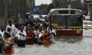
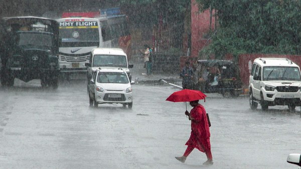
LUCKNOW: Extreme weather conditions are the new ‘normal’ these days and the ongoing extreme rainfall is taking place in only some regions, while many others are having deficient rainfall, said Venkatesh Dutta, river expert and associate professor, Babasaheb Bhimrao Ambedkar University (BBAU) here on Friday.
The state capital and several parts of Uttar Pradesh experienced heavy rainfall during the last 48 hours. Yet several districts in the state are facing rain deficit, he said.
According to the IMD website, Ghaziabad is driest district in UP with 73% rain deficit, Meerut recorded rain deficit of 34%, Agra 18%, Varanasi 17%, Kanpur 12% and Gorakhpur 9%.
The website mentioned that Balrampur was the wettest district with 41% surplus rainfall.
Dutta said, “Monsoon withdrawal has been delayed this year. Normally monsoon begins to retreat by the first week of September, but this year it may go up to first week of October. The extended monsoon has broken its 60-year-record as per IMD data. The impact is more visible because we have encroached upon water bodies and natural drainage system.”
“The extreme events remind us about the river land that we have encroached,” he said.
Saroj Chattree, geography teacher at La Martiniere Girls’ College, Lucknow said, “Monsoons are seasonal winds that reverse their direction with the change of seasons. All winds blow from an area of high pressure to an area of low pressure. However, due to global warming, this cycle is disturbed.”
“Hence monsoons, which are said to be erratic, become more unpredictable. Therefore, we had deficient rainfall in July-August, the peak monsoon period. Monsoon normally retreats by September 30, but due to a low pressure trough formed from eastern Maharashtra to eastern UP there are heavy rains in this region,” Chattree said.
An official of the Meteorological Centre, Lucknow said a cyclonic circulation was lying over south-west Uttar Pradesh and its neighbourhood. Subsequently, an east-west trough in the lower levels is likely to develop over the Indo-Gangetic plains during next the two days. A low pressure area is likely to form over north Bay of Bengal and it neighbourhood by Saturday, which could become more marked subsequently, thus leading to more rainfall, he said.
“Moisture incursion and strong convergence in the easterly wind is likely to cause fairly widespread to widespread rainfall with isolated, heavy to very heavy and extremely heavy rainfall likely over Bihar during the next 3 days and heavy to very heavy rainfall over sub-Himalayan West Bengal and Sikkim, Uttarakhand and Himachal Pradesh during the next 3-4 days,” said JP Gupta, met director, Lucknow.