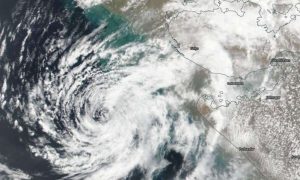
With Cyclone Vayu set to make landfall in Gujarat on June 13, the India Meteorological Department (IMD) today said thunderstorm and lightning accompanied by gusty wind are likely to occur in the southern districts of the state. After taking stock of the current weather condition, the IMD has issued a red alert in the wake of the cyclonic storm and predicted a heavy downpour at several areas in Gujarat. The state government has already begun a massive evacuation exercise to shift about three lakh people from low-lying areas of Saurashtra and Kutch regions.
Here are 10 things to know about Cyclone Vayu:
Areas likely to affect
Cyclone Vayu is likely to hit Kutch, Morbi, Jamnagar, Junagadh, Devbhoomi-Dwarka, Porbandar, Rajkot, Amreli, Bhavnagar and Gir-Somnath districts.
Gujarat CM appeals tourists to leave for a safer place
Gujarat Chief Minister Vijay Rupani has appealed the tourists visiting the state to leave for a safer place after the afternoon of June 12, in the view of Cyclone Vayu which is likely to hit with a wind speed of 110-120 kmph gusting to 135 kmph on the morning of June 13. In an interview to ANI, Rupani said, “I request the tourists visiting Gujarat and going to Dwarka, Somnath, Sasan, Kutch, to leave for safer places after the afternoon of June 12 that you don’t get harmed due to the cyclone. If it is possible, you can go back, it is a request.”
Advice to fishermen
According to ANI, fishermen have been advised not to venture into the sea along and off Gujarat coast from June 12 to 15 as well as into East-central Arabian Sea and along and off Maharashtra Coast today and into the northeast Arabian Sea from June 12-13.
Thunderstorm warning issued
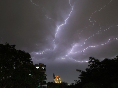
Thunderstorm and lightning accompanied by gusty wind are likely to occur at isolated places in the districts of North Gujarat region on June 13, IMD said on Wednesday. In a statement issued by the IMD, it reads, “It is very likely to move nearly northwards and cross Gujarat coast between Porbandar and Mahuva around Veraval and Diu region as a very severe cyclonic storm with wind speed 140-150 kmph gusting to 165 kmph around the morning of 13 June 2019.” The statement also reads, “Heavy to very rains very likely at a few places with extremely heavy fall in districts of Saurashtra namely Junagadh, Amreli, Gir Somnath, Diu. Heavy to very rains very likely at a few places in districts of Saurashtra namely Rajkot, Jamnagar, Porbandar, Dwarka, Bhavnagar.”
Evacuation begins in Gujarat
The state government launched a massive evacuation exercise to shift about three lakh people from low-lying areas of Saurashtra and Kutch regions. Gujarat CM Vijay Rupani has appealed to people to cooperate in the evacuation process so that no life is lost due to the cyclone.
Preparations in place
According to ANI, all preparations are in place to deal with any emergencies arising of the cyclone Vayu’s impact, authorities said here on Wednesday. Humanitarian Assistance and Disaster Relief (HADR) materials are on board nominated ships and medical teams and facilities are on standby to handle medical emergencies at the Indian Naval Hospital Asvini. An IAF aircraft C-17, which took off from New Delhi, will airlift around 152 NDRF personnel and eight tonnes of necessary equipment from Arakkonam to Jamnagar for HADR missions in Gujarat.
Schools, colleges to remain shut
As a precautionary measure, the holiday has been declared in schools, angandwadis and colleges will remain closed on June 12 and 13.
IMD predicts a windy day in Maharashtra
Deputy Director General, IMD, KS Hosalikar while speaking to ANI said that the sea conditions in Maharashtra are likely to be rough. He was quoted saying, “There is a potential threat from flying objects. Sea conditions are very likely to become rough to high along and off Maharashtra coast on June 12 and 13. Sea beaches will require special attention. Fisherman warnings have been issued. Gusty winds can cause tree falling incidences too.”